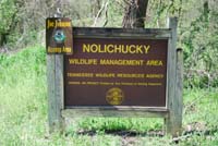
Nolichucky WMA
Site Directions: From the Greene County Courthouse in downtown Greeneville, follow Main Street south out of town. It curves west at the bottom of the hill. At the outskirts of town take Hwy 70 south several miles. Follow Hwy 70 past Nolichucky Dam and turn left on Hwy 351. Follow Hwy 351 for several miles to Little Indian Creek Rd, which is a narrow two lane road that takes you to the bridge and the best access to the WMA. You may also follow the directions to Kinser Park and continue past the park and make a right at the "T" in the road. This is Old Ashville Hwy (Birds Bridge Rd) and brings you to the boat ramp from the north.
Lat: 36.086585°N Long: -82.824962°W
Hours: day light hours
Seasonality: year round
Fees: none

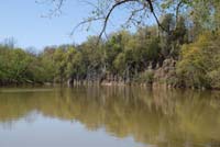
Site Description: The WMA is primarily floodplain forest with some fields. The boat ramp at the bridge is the best access to the WMA and provides a viewing area of the river and access to a small trail worn in by local fisherman. The trail is just a sandy trail through the woods along the river bank, but is nice to explore. The trail peters out after 150 yards or so, but you can explore more on "deer trails" along the bank.
Kinser Park is nearby and worth exploring while in the area.

Wildlife to Watch: General woodland birding is good. In spring and summer, Cliff Swallows nest under the big bridge. Great Blue Herons frequent the area.
NOTE: Please refer to TWRA Hunting Guide about hunting seasons and public access dates. Access dates vary by site.
Submit your data to eBird and help us build a list of birds seen at this site
Be sure to check out our Safety Tips page for important information regarding viewing wildlife in these areas.


